|
||||||
|
||||||
|
|
||||||
|
Skipulag vegna útsýnisflugs yfir Reykjanesi /
Procedures due to sightseeing over Reykjanes peninsula |
||||||
Due to volcanic activity at Reykjanes peninsula for the last years and foreseen eruptions the Icelandic Transport Authority, in cooperation with Isavia ANS, has updated procedures to maintain safety of flight and better serve the needs of the airspace users while sightseeing over Reykjanes pensual.
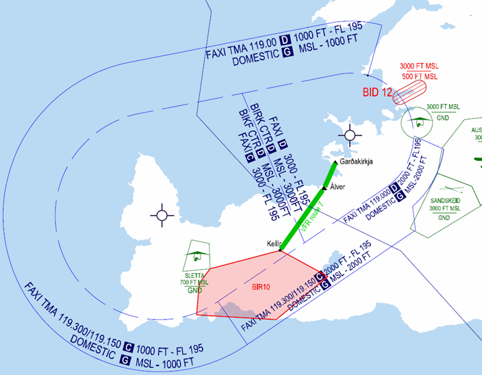
A new restricted area (BIR10) has been defined and a VFR route between that area and Reykjavik airport (BIRK). Restricted area and VFR route are published with NOTAM.
NOTAM will also be published due to airspace changes such as establishing prohibited area within the restricted area.
BIR10 is defined by direct line between:
Litla Skogfell (635424N 0222512W)
Keilir 63563027N022101228W,
Kleifarvatn 63541461N021593320W,
Husholmi 63495123N022101737W,
Ras (Grindavik) 63495500N022273600W,
Blue Lagoon parking lot 63525800N022272400W.
Keilir 63563027N022101228W,
Kleifarvatn 63541461N021593320W,
Husholmi 63495123N022101737W,
Ras (Grindavik) 63495500N022273600W,
Blue Lagoon parking lot 63525800N022272400W.
Class of airspace: G
Upper limit: 2000 feet AMSL
Lower limit: GND
Upper limit: 2000 feet AMSL
Lower limit: GND
Two antennas are near Grindavík, identified with a light in the center and on top, see ENR 5.4.1.
Pilots shall take notice of guy wires supporting antennas.
Due to the volcanic eruption, loss of electricity is possible, pilots are advised to monitor NOTAM publications.
BIKF TWR, BIRK TWR and FAXI issues clearances into BIR10 on the pilot requests.
Attention is drawn to that a clearance is required before entering and leaving CTR and TMA from the appropriate tower or approach, see chart in chapter 6.
It is imperative that pilots
always
contact ATC
before
leaving BIR10.
Flights on behalf of Department of Civil Protection and Emergency Management have priority for BIR10.
Isavia will restrict the use of BIR10 in accordance with the decisions of the authorities.
Announcement on restriction of the use of BIR10 will be on 131.8 MHz, in BIKF and BIRK ATIS and NOTAM as applicable. Pilots shall check restrictions of the area via ATIS before departure.
Restrictions: Transponder. Monitoring requirement and Air to Air communications on 131.800 MHz.
The Police and the Department of Civil Protection and Emergency Management will publish other restricted areas, those areas will also be published by NOTAM.
VFR route 7 between BIRK and BIR10 at 2000 feet for helicopters and 1500 feet for airplanes via Gardakirkja direct Aluminum factory direct Keilir.
Flying via the new route should be like flying on other VFR routes, it is important that pilots keep well to the right of centreline of the route, so as to maintain not less than 45° angle from the centreline (with reference to surface) to aircraft.
An exemption is made for microlight operation from Heidi to BIR10 via Kleifarvatn while NOTAM is active. The exemption is not valid if BIR10 is unavailable.
Microlight operations between Heidi and BIR10:
- An approval to enter BIR10 shall be requested from Reykjavik TWR as soon as possible after departure from Heidi.
- The flight in and out of BIR10 shall be outside BIRK CTR, BIKF CTR and below FAXI TMA via Kleifarvatn.
- BIRK TWR will instruct frequency change to BIR10 frequency
- Departing BIR10 shall be via Kleifarvatn, a report shall be made to BIRK TWR when leaving BIR10 and when the FPL is closed.
Airspace within BIR10 is classified as Class G.
Rules of the air apply to flying within the Area.
Rules of the air apply to flying within the Area.
Pilots are urged to use extreme caution due to possible heavy traffic and risk of mid-air collision.
Attention is drawn to possible restricted or prohibited areas within BIR10 published via NOTAM.
The training area Sletta is also located partly within BIR10 and is activated and notified via BIKF ATIS.
The training area Sletta is also located partly within BIR10 and is activated and notified via BIKF ATIS.
Increased likelihood of drone flight may be expected within BIR10 up to approximately 400 feet (120 meters) above ground.
The following may be contacted for information or to provide feedback:
AIP Supplement cancelled:
AIP SUP 02/2025
NOTAM incorporated in this AIC:
NIL
ENDIR / END